Hurricane warnings are in place from Grand Isle, La., to the Alabama border with Florida. This includes the city of New Orleans, which has prompted the mayor of the Crescent City to issue mandatory evacuations for parts of the area.
Nate is expected to make landfall Saturday night, now as a Category 2 storm with 105 mph sustained winds. Rain had already begun along the northern Gulf Coast Saturday morning, and conditions will go downhill further through the afternoon and Saturday night.
In the region under a hurricane warning, a dangerous combination of damaging winds, gusting over 100 mph at times, severe coastal flooding, and torrential rain are likely.
Nate is the ninth hurricane to form in the Atlantic this season, which is the highest total since the infamous 2012 season featuring Hurricane Sandy.
Nate, which started forming earlier this week in the southwestern Caribbean, reportedly killed 25 people as it passed along Central America.
Since Friday, Nate has steadily become better organized over the warm waters of the Caribbean and southern Gulf of Mexico. While some wind shear is preventing the storm from explosively intensifying, Nate is expected to strengthen right up until landfall.
The inner bands of the storm are still located offshore, but with Nate’s fast forward motion, wind speeds and rain intensity will increase throughout Saturday. While landfall is expected to occur Saturday night, tropical storm force are likely to move into the Louisiana coast by midafternoon. They should be impacting Mississippi and Alabama near or shortly after sunset.
Nate is expected to make landfall as a Category 2. Sustained hurricane-force winds and gusts over 100 mph likely to affect some locations from Southeast Louisiana to the near the Alabama-Florida border. These winds could cause widespread downed trees and power outages, as well as some structural damage. The most severe damage will tend to be concentrated in a relatively narrow zone near and just to the east of the storm center. Hurricane-force winds extend about 35 miles from the center, mainly on the east side.
But wind may not be the most dangerous hazard from Nate.
The most immediate threat for the coast will be storm surge generated from the hurricane. Storm surge is best thought of as a general rise in the water level at the coast as the storm comes ashore. It does not include waves on top of it. Water levels as high as 7 to 11 feet above normally dry ground are expected in the hardest hit parts, which the National Hurricane Center expects to be from roughly from the mouth of the Mississippi River to the Mississippi-Alabama border. Around that — as far west as Morgan City, La., and as far east as the Okaloosa-Walton County line in Florida, less severe but still problematic water rises are anticipated — and this whole zone is under a storm surge warning.
“Unfortunately, locations from Grand Isle, La., to Panama City, Fla., will have high tide around midnight, coinciding with landfall and peak storm surge, maximizing coastal inundation anywhere east of the landfall point,” said Brian McNoldy, Capital Weather Gang’s tropical weather expert
On top of the surge, there are giant waves. Nate is already generating wave heights upward of 24 feet in the Gulf of Mexico. While heights seen in open water are unlikely to make it to shore, battering waves are likely to accompany surge along the coast, especially to the east of the center.
Forecast trending to the east of New Orleans
The first round of model runs this morning showed a bit of an eastward shift in Nate’s forecast. If this occurs, it would keep New Orleans on the west, and generally less intense, side of the storm. Given Nate’s fast movement and imminent arrival of bad weather, there’s no reason to let any guard down in these areas, even if the worst misses.
In New Orleans itself, the city’s pumping system is still reeling from several heavy rain events over the summer, with 11 of the 109 city wide pumps still out of service as of earlier this week. Rain from the outer edges of Nate has already reached the area Saturday morning.
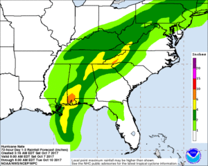
Nate will also be carrying a lot of moisture and promises to drop a large amount of rainfall, despite the fact that the storm is moving quite fast.
A widespread 2 to 6 inches of rain is expected to fall along its track through Sunday. Higher amounts are likely in spots. All of this rain will fall in under 24 hours, so flash flooding will be a concern.
Because the storm is moving so fast, tropical storm-force winds, which could down trees and cause power outages, may extend fairly far inland — through much of Alabama. The National Hurricane Center predicts it could sustain tropical storm strength into Sunday evening, when it should be passing through Tennessee.
Both the “cone of uncertainty” for Nate’s future path and the rainfall forecast for the system include the Mid-Atlantic and Northeast as well. What’s left of Nate will pass west of Washington on Sunday, but we will still be close enough to tap into some much needed rain.


